MSoftech · Nov 2023 – Jun 2024

AI Geological Analysis

An address-based geological survey system that evaluates hot spring development feasibility through AI — scoring geological conditions, estimating yield and cost, and assessing drilling risks to support multi-billion-won investment decisions before breaking ground.

A+
AI Grading
6
Risk Factors
1.5km
Depth Analysis
800m Deep Hot Spring Development Scenario
Overview

Project Overview

AI Geological Analysis is a feasibility assessment platform for hot spring development. Given any address in Korea, the system analyzes geological data — rock types, fault structures, fracture zones, geothermal gradients — from the Korea Institute of Geoscience and Mineral Resources (KIGAM) and generates a comprehensive AI report with development grade, estimated yield, projected cost, and risk evaluation.

Hot spring development is a high-stakes investment — often exceeding billions of won — where failure means total loss. This system automates the initial feasibility assessment that traditionally required expensive geological consultants, enabling developers to make data-driven go/no-go decisions with AI-scored confidence levels before committing capital.

Period
Nov 2023 – Jun 2024
Type
MSoftech Product
Role
AI Solutions Architect · Full-Stack Engineer
Domain
Geology · Hot Spring Development · Risk Assessment
Domain Expertise

Independent Domain Research

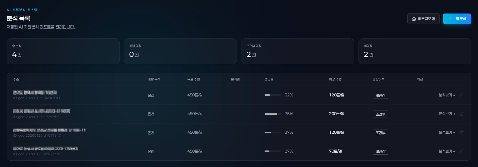
Building AI Geological Analysis required deep understanding of geoscience, hot spring regulations, and drilling engineering — domains far beyond typical software development. MSoftech independently studied geological survey methodology, Korean hot spring law (온천법), drilling cost structures, and risk assessment frameworks before designing the system architecture.

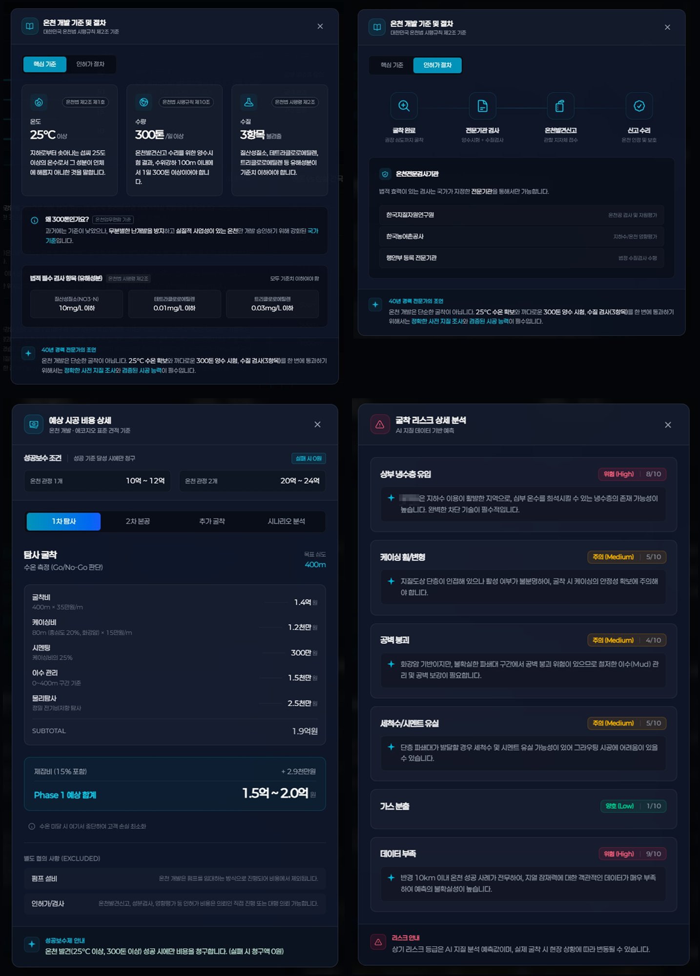
Hot Spring Development Law
Korean Hot Spring Act Article 2, enforcement rules, permit requirements (25°C+, 300 tons/day), and regulatory approval processes for commercial development.
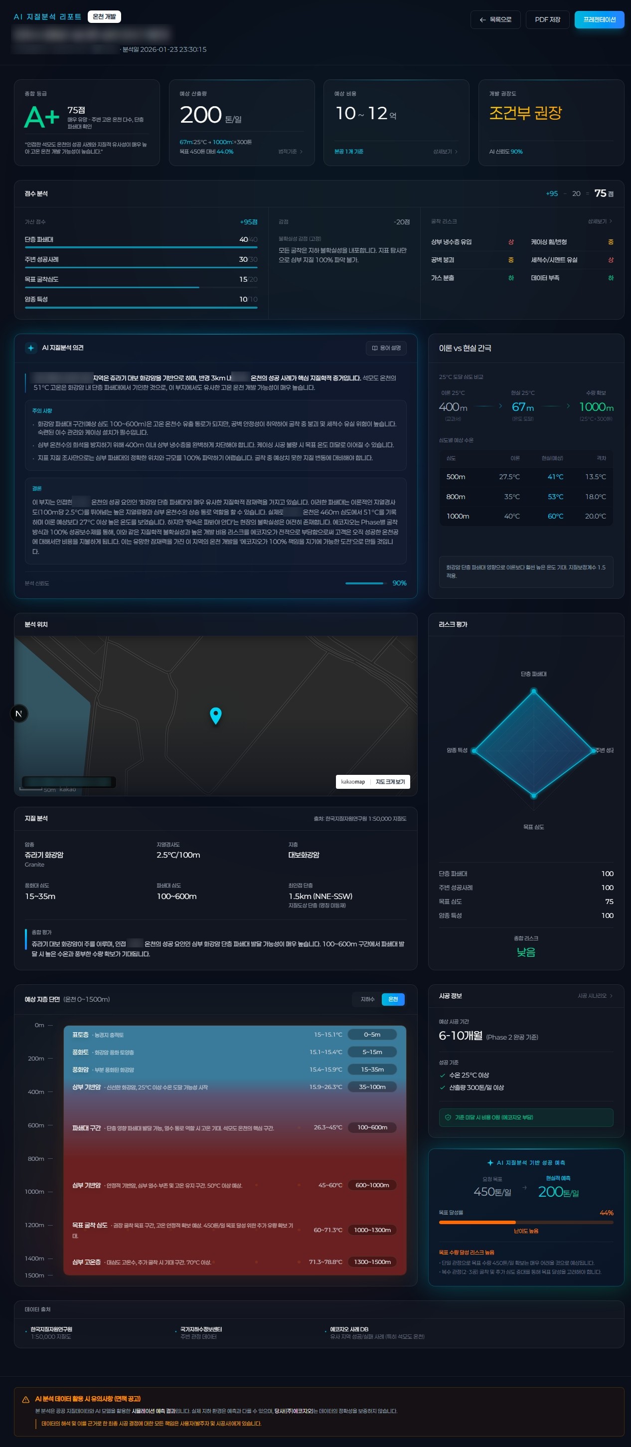
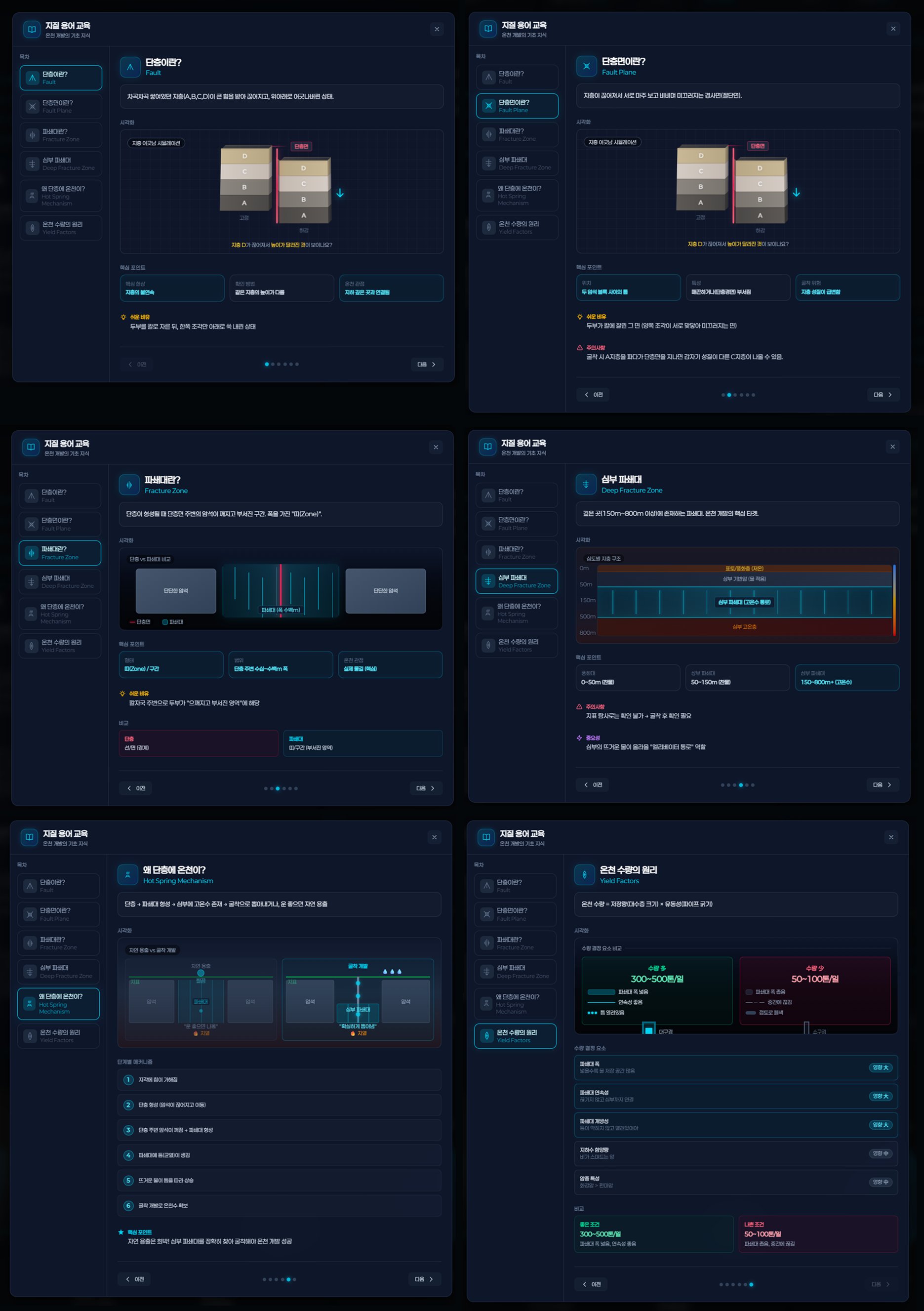
Geological Fundamentals
Rock type classification (granite, gneiss), fault and fracture zone analysis, geothermal gradient interpretation, and 1:50,000 geological map reading methodology.
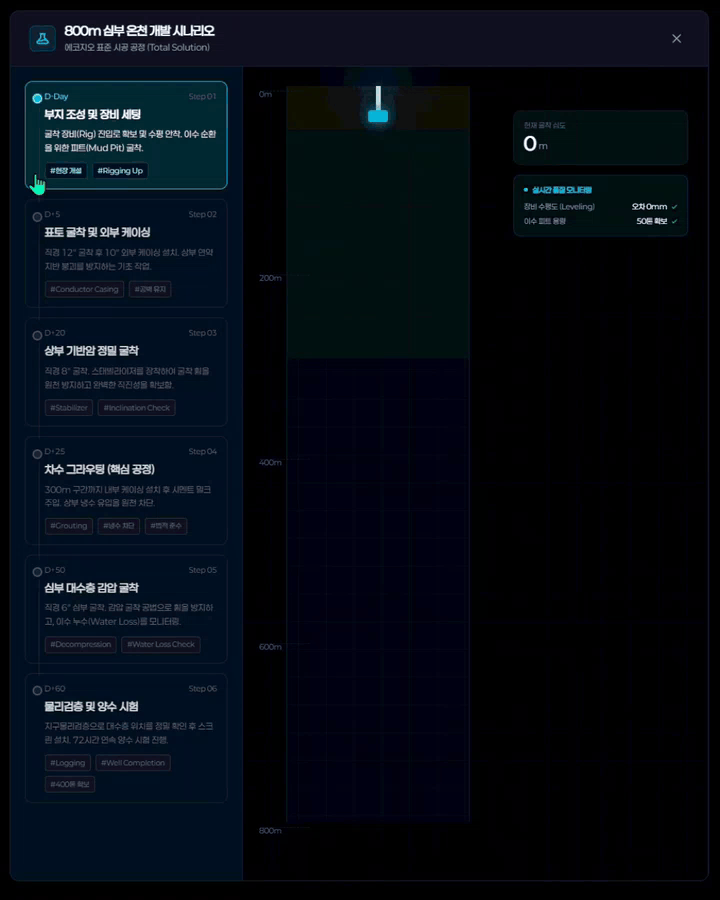
Drilling Process Engineering
6-phase construction process from rigging to well completion, casing design, grouting techniques, decompression drilling, and 72-hour pump testing protocols.
Risk Assessment Framework
6 risk factors — cold water intrusion, casing failure, cavity collapse, cement/grout loss, gas emission, and data scarcity — with severity scoring and mitigation strategies.
Public Data Integration
Korea Institute of Geoscience and Mineral Resources (KIGAM) 1:50,000 geological maps, National Groundwater Information Center data, and Eco-Geo case study databases.
From geological research and regulatory analysis to system architecture, UI/UX design, AI pipeline development, and full-stack engineering — MSoftech delivered every phase independently as a single integrated team.
Core Feature

AI Geological Analysis Report

The system's core output — a comprehensive AI report that evaluates hot spring development feasibility from every angle. Each report delivers an overall grade (A+ to D), geological scoring across 5 dimensions, AI-generated development opinions, theory-vs-reality gap analysis, geological cross-section visualization, 6-factor risk assessment, and detailed construction cost estimation.

AI Geological Analysis Report
01
Overall Grade
A+ to D grading based on weighted scoring across 5 geological dimensions — fault distance, success rate, target depth, rock hardness, and formation characteristics.
02
AI Development Opinion
AI-generated geological interpretation with development recommendations, confidence level, and analysis reliability scoring based on available data quality.
03
Theory vs Reality Gap
Comparison between theoretical geological predictions (temperature at depth, expected yield) and real-world drilling outcomes from comparable sites.
04
Geological Cross-Section
Depth-based visualization (0~1,500m) showing rock layers, fracture zones, temperature gradients, and estimated aquifer locations with drilling target markers.
05
Risk Assessment
6-factor risk scoring — cold water intrusion, casing damage, cavity collapse, cement loss, gas emission, and data scarcity — with High/Medium/Low severity levels.
06
Construction Cost Estimate
Phase-by-phase cost breakdown — drilling, casing, cement, testing, logging — with total estimate range and success-based billing conditions.
Key Screens

Data Modules

Analysis List
Analysis List
Analysis List & Management
Saved AI geological analysis reports with summary statistics — total analyses, recommended, conditional, and not recommended counts. Each entry shows address, development purpose, target yield, success rate, estimated yield, and recommendation status.
Development Standards & Cost Detail
Detail Popup
Development Standards & Drilling Cost
Hot spring development requirements (temperature, yield, water quality standards), regulatory approval process, phase-by-phase drilling cost breakdown, and AI-powered drilling risk analysis with severity scoring.
Geology Education
Geology Education
Geological Terminology Education
Interactive geology education module covering faults, fault planes, fracture zones, deep fracture structures, hot spring mechanisms, and yield factors — with visual diagrams and step-by-step explanations.
800m Drilling Scenario Simulation
Development Scenario
Development Scenario Simulation
6-phase drilling simulation (D-Day to D+60) with real-time depth visualization, equipment monitoring, and step-by-step construction progress — from rigging and surface casing through grouting, deep drilling, and pump testing.
System Architecture

Service Flow

The system takes an address input and retrieves geological data from KIGAM 1:50,000 maps and the National Groundwater Information Center. The Spring Boot API processes this data through an AI analysis pipeline that evaluates geological conditions, estimates yield and cost, and generates a structured feasibility report with grade scoring and risk assessment.

AI Analysis Pipeline Geological Scoring (5 dimensions) Fault Distance Success Rate Target Depth Rock Hardness Formation Type Risk Analysis (6 factors) Cold Water Intrusion Casing Damage Cavity Collapse Cement Loss Gas Emission Data Scarcity Cost Estimation Drilling · Casing · Grouting · Testing · Logging → Total Estimate AI Report Output Overall Grade (A+~D) Score Analysis AI Development Opinion Theory vs Reality Gap Geological Cross-Section Risk Assessment Construction Cost Estimation PDF Data: KIGAM 1:50,000 Geological Map · National Groundwater Information Center · Eco-Geo Case DB Engine: Google Vertex AI · Gemini · Prompt Registry
Results

Impact

A+
AI Grading System
Automated feasibility grading
across 5 geological dimensions
6
Risk Factors Analyzed
Comprehensive drilling risk
assessment with severity levels
1.5km
Depth Coverage
Geological cross-section analysis
from surface to 1,500m depth
E2E
Independent Development
Domain research to deployment
delivered as a single team
Technology

Tech Stack

Frontend
React 18 TypeScript Recharts Kakao Maps
Backend
Spring Boot Java 17 JPA RESTful API
AI Engine
Google Vertex AI Google Gemini Prompt Registry
Data
PostgreSQL KIGAM DB Groundwater DB Eco-Geo Cases